Health Deserts and Conflict Hotspots in Four African Countries
Mapping population density, healthcare access, and conflict intensity across Sudan, Chad, Mali, and the Democratic Republic of the Congo
Why These Four Countries?
This visualization compares four Sub-Saharan African countries — Sudan, Chad, Mali, and the Democratic Republic of the Congo — each representing a different stage of stability and development.
Sudan and the Democratic Republic of the Congo have faced prolonged armed conflict and political instability,
Chad remains relatively stable but deeply affected by regional spillovers,
and Mali shows localized insurgencies in an otherwise calmer landscape.
Together, they illustrate how conflict intensity, population concentration, and healthcare access intersect across diverse sociopolitical and geographic contexts.
2. Conflict Intensity and Population Overlap
In Sudan and the Democratic Republic of the Congo, the most severe conflict impacts, measured by fatalities, are highly concentrated and spatially clustered.
Several districts in Sudan record over 500 conflict-related deaths in 2025, with the most affected areas reaching a maximum of approximately 4,705 fatalities, reflecting the extreme intensity of ongoing violence. Similarly, parts of eastern Democratic Republic of the Congo exceed 500 fatalities, highlighting persistent and lethal insecurity.
These high-fatality hotspots closely overlap with densely populated areas, intensifying humanitarian vulnerability: communities already under demographic pressure face heightened exposure to violence while simultaneously experiencing severe disruption to essential healthcare access.
By contrast, Mali displays a markedly lower fatality concentration, with district-level peaks around 300 deaths, primarily in the northern and central regions. Chad remains the least affected among the four countries, with most districts recording fatality levels below 100, indicating comparatively lower conflict severity.
3. The Sudan-Chad Border: Refuge, Pressure, and Health Infrastructure
A striking pattern emerges along the Sudan-Chad border.
While many Sudanese conflict zones lack adequate healthcare facilities, a cluster of clinics and hospitals appears just across the border in Chad, especially near refugee reception areas.
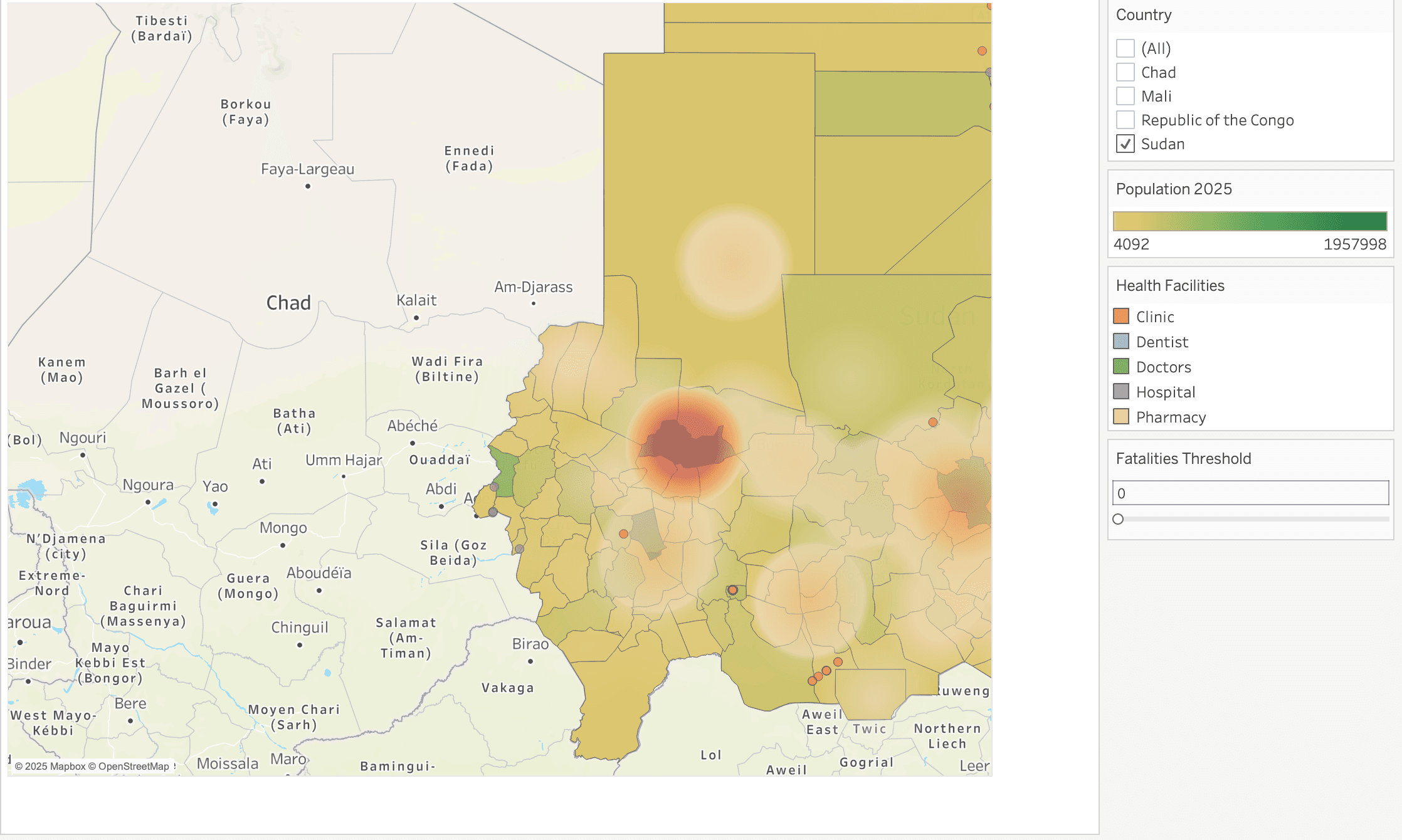
(Only a few health facilities near the conflict zone in Sudan)
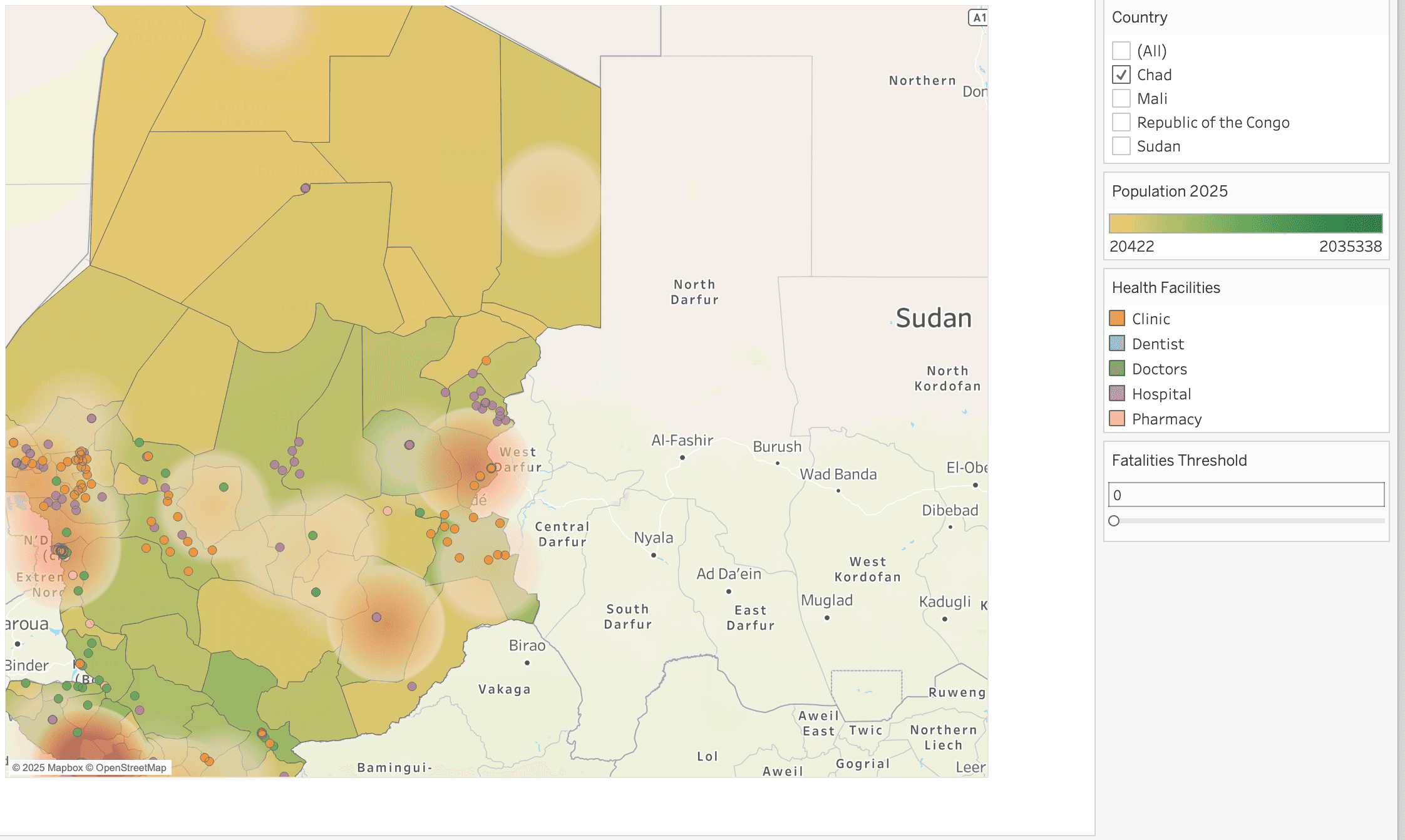
(While once crossing the border, there are quite a lot health facilities in Chad)
Reports by UNHCR and UNICEF indicate that the Sudan–Chad border region hosts hundreds of thousands of Sudanese refugees. Humanitarian sources suggest that in certain border districts or settlements, displaced people make up a major share of the population — in some areas, as many as one in two residents are refugees or internally displaced persons.
Despite its own poverty and limited infrastructure, Chad has kept its borders open, hosting hundreds of thousands of Sudanese refugees fleeing violence since 2023.
This humanitarian openness has turned border towns into critical health access points — not only for refugees but also for host communities.
4. The Northern Health Desert
Across northern Chad, Sudan, and Mali, the map shows vast areas with little to no health infrastructure. This is the Sahara Desert belt, where extremely low population density, harsh climate, and logistical barriers make facility construction and staffing difficult. These regions form what could be termed “health deserts” — large geographic zones with minimal formal access to medical care.
5. The Democratic Republic of the Congo: Dense Health Networks Amid Eastern Conflict
In contrast, the Democratic Republic of the Congo (especially around Kinshasa, population ~9.5 million) shows the densest concentration of health facilities among the four countries.
Interestingly, conflicts in the Democratic Republic of the Congo are concentrated in the east, near resource-rich zones, while the western capital region combines high population density with high healthcare access — a sharp contrast within the same country.
6. Mapping Key Takeaways
Conflict hotspots and population density frequently overlap, heightening humanitarian risks.
Border regions (Sudan–Chad) act as both pressure points and humanitarian buffers.
Northern arid regions remain underserved, forming vast “health deserts.”
Urban centers, particularly Kinshasa, demonstrate what well-developed facility networks can look like — but also highlight inequality across regions.
When Violence Concentrates: The Rising Human Toll of Modern Conflict
This chart compares long-term conflict dynamics and civilian fatalities in Chad, the Democratic Republic of the Congo (DRC), Mali, and Sudan over nearly three decades. Two key patterns emerge across all countries: civilian deaths frequently far exceed the number of recorded conflict events, and sharp spikes in fatalities are often driven by isolated but extremely violent episodes rather than gradual escalation.
Overall, fatalities show greater volatility than conflict events, highlighting how modern conflicts increasingly target civilian populations. In several cases, relatively stable levels of conflict activity coincide with sudden surges in deaths, reflecting episodes such as mass killings, retaliatory attacks, or large-scale assaults on populated areas.
Sudan presents the most dramatic trajectory, with multiple peaks corresponding to the Darfur conflict in the early 2000s and a severe escalation following the outbreak of civil war in 2023-2024. These spikes suggest a shift from dispersed violence to highly concentrated episodes of mass civilian harm.
In the DRC, elevated fatality levels in the early 2000s align with the Second Congo War, while the sharp rise between 2020 and 2022 reflects intensified violence by ADF militias, marked by coordinated attacks on villages and civilians in eastern regions.
Mali demonstrates a more gradual but sustained increase in both conflicts and fatalities since the mid-2010s, consistent with the expansion of jihadist insurgencies and growing regional instability. Chad, by contrast, remains relatively lower in overall magnitude but still exhibits periodic spikes linked to specific rebel offensives and cross-border insecurity.
Across all four countries, the data suggests that the human cost of conflict is not merely a function of how often violence occurs, but how intensely it impacts civilian populations with mass-casualty events playing a disproportionate role in shaping long-term human suffering.
8. Data Sources
Population (2025, 100 m grids)
WorldPop Hub — Country 100 m Population (R2025A).
Source: WorldPop, University of Southampton.
Contributor: WorldPop Research Group.
License: Creative Commons Attribution 4.0 (CC BY 4.0).
Dataset link: https://hub.worldpop.org/geodata/summary?id=79391
Administrative Boundaries (ADM2)
Humanitarian Data Exchange (HDX) — Sudan: Administrative Boundaries (COD-AB).
Source: Information Management Working Group (IMWG), OCHA.
Contributor: OCHA Regional Office for Southern and Eastern Africa (ROSEA).
License: Creative Commons Attribution for Intergovernmental Organisations (CC BY-IGO).
Dataset link: https://data.humdata.org/dataset/cod-ab-sdn
Health Facilities (points)
Humanitarian Data Exchange (HDX) — Sudan: Healthsites.
Source: OpenStreetMap contributors.
Contributor: Global Healthsites Mapping Project.
License: Open Database License (ODbL).
Dataset link: https://data.humdata.org/dataset/sudan-healthsites
Conflict Events and Fatalities (2025)
Humanitarian Data Exchange (HDX) — Chad: ACLED Conflict Data.
Source / Contributor: Armed Conflict Location & Event Data Project (ACLED).
License: ACLED Terms of Use and Attribution Policy.
Dataset link: https://data.humdata.org/dataset/sudan-acled-conflict-data
Note: Equivalent datasets for Chad, Mali, and the Democratic Republic of the Congo were retrieved from the same platforms (HDX and WorldPop Hub) using country-specific administrative and population layers.
9. Key Skills Demonstrated
Data cleaning and spatial processing in R.
Geospatial visualization and dashboard design in Tableau.
Integration of multi-source datasets (WorldPop, OCHA, ACLED, Healthsites) for cross-country comparison.